
July 4, 2018
The Fell House Garden Honors July 4
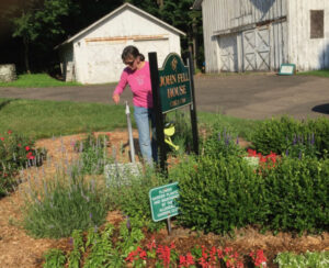
Noticed one of the terrific Allendale Garden Club members -- Kathy Vorhis --working in the Fell House garden on Sunday,…

While sniffing around the Internet the other day, I came across a new reference to what is now the Celery Farm.
As you may know, the area was called "Wolf Swamp" in colonial days, and Native Americans reportedly had a meeting site there.
But I just came across this citation in a work called "A Dictionary of Place Names in Bergen County, New Jersey and Vicinity," by former long-time Allendale Historian Patricia Wardell:
FELL’S MEADOWS
Marshy area in Allendale, Bergen County, N.J., northeast of the intersection of Franklin Turnpike and Cottage Place.
Also known as Wolf Swamp. Later (c. 1900 and after) known as “the celery farm” and “Appert’s Farm,” after the Allendale Produce Gardens, run by the Appert family here. A large portion of it is now a wildlife refuge.
• August 1778, "Fell's Meadows"—shown on Erskine-DeWitt Map No. 26 (New York Historical Society), drawn from surveys made by Capt. John W. Watkins, August 1778. [Map is above]
Robert Erskine and Simeon DeWitt were noted regional cartographers. Fell's Meadows was clearly named for the owner of the property, John Fell, for whom the Fell House is also named. The map was drawn about six months after Fell was released from the Provost Jail, a British prison in New York City, where he had been held because of his efforts against the crown.
A low-res version of the map is above. More information on the map is here.
You can download Wardell's dictionary here:
Download Bergen_county_new_jersey_dictionary_place_names
July 4, 2018

October 4, 2016

February 1, 2016
January 21, 2016