
February 7, 2024
Please Take This High Mountain Survey
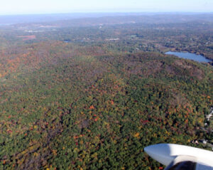
Credit: TNC/LightHawk/Jim Wright I am a big fan of High Mountain -- especially the views from the summit and…

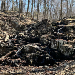
Last Monday, I asked what this was. Folks who went on the April hikes to High Mountain summit knew the answer:
The copper bolt from a National Geodetic Survey marker that was used to help map the region back in the 1880s.
Here's the datasheet for the National Geodetic Survey marker on High Mountain, courtesy of Gail Grove:
http://www.ngs.noaa.gov/cgi-
Here's a description from back then.
DESCRIBED BY COAST AND GEODETIC SURVEY 1883 (EAB)
STATION IS ON THE SUMMIT OF THE ELEVATION OF THAT NAME, ONE OF
THE HIGHEST OF BREAKNESS RANGE.  IT IS ABOUT 3 MILES N OF PATERSON,
3/8 MILE W OF ROAD LEADING THERETO, AND 1/2 MILE S OF THE BOUNDARY
BETWEEN PASSAIC AND BERGEN COUNTIES.  PHILIP ORRS HOUSE IS ABOUT
1/8 MILE W OF THE PATERSON-FRANKLIN LAKE ROAD, AND ABOUT 3/8
MILE SSE FROM THE STATION.  A FOOTPATH LEADS FROM THIS HOUSE TO
THE SUMMIT.  THE STATION IS MARKED BY A COPPER BOLT SET IN A
HOLE DRILLED IN THE ROCK.  REFERENCE MARKS ARE PLACED AS
FOLLOWS--NO.1 IS AN ARROW HEAD CUT ON AN OUTCROP OF LEDGE, IS 11
FEET E OF THE STATION.  NO.2 IS AN ARROW HEAD CUT IN LEDGE, IS
48 FEET S BY E FROM THE STATION.  NO.3 IS AN ARROW HEAD CUT ON
TOP OF OUTCROP OF LEDGE, IS 55 FEET 2 INCHES WSW OF THE
STATION.  NO.4 IS AN ARROW HEAD CUT ON TOP OF A LEDGE, IS 98
FEET NNE OF THE STATION.

You can get more information on these markers here.

(A thank you to NJUrbanforest for passing this along originally.)
February 7, 2024
March 21, 2023

February 24, 2023
February 17, 2023