

May 24, 2026
My New Book Is Here
I am pleased to report that The Peregrine Falcon from Schiffer Books -- the folks who did such a beautiful…

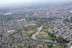
Last week, I took some aerial photographs of the Celery Farm to document current conditions and marsh life. The day was overcast, but still got some decent shots.
The shot above is the south end Lake Appert, including the Warden's Watch. You can also see how close to downtown Allendale is to the Celery Farm.That's the train track in the upper right.
This is the north end of Lake Appert, including the Boy Scout Platform. That dark line on the left-hand side of the photo is Parnell's Path.
This is a view of the Celery Farm looking north. You can still see a few of the furrows left from the old working-farm days.
Is that Patty standing on Franklin Turnpike waving to you???
Nice photos! It’s amazing that, from ground level within the Celery Farm, so few signs of civilization (except those condos)can be seen, at least in summer, considering how close everything is.

May 24, 2026
May 24, 2026
May 15, 2026

May 5, 2026
2 comments
Carol Flanagan
Is that Patty standing on Franklin Turnpike waving to you???
Tom Burr
Nice photos! It’s amazing that, from ground level within the Celery Farm, so few signs of civilization (except those condos)can be seen, at least in summer, considering how close everything is.